
Alaska 2008
DeForest, WI to Sioux Falls, SD
19 June 2008
Route Map
Destination Map
Route Information
City/Town |
Points of interest |
Distance From |
Miles/Km |
Waypoint |
State/ |
Highway |
|---|---|---|---|---|---|---|
| DeForest, WI | KOA-Madison | Home Sioux Falls |
1008/1613 415/664 |
43.250 N 89.373 W |
WI |
I 90 I 39 Cty Road V |
| La Crosse, WI | Home DeForest Sioux Falls |
1131/1810 123/197 292/467 |
43.866 N 91.230 W |
WI | I 90 | |
| Rochester, MN | Mayo Clinic | Home DeForest Sioux Falls |
1193/1909 185/296 230/368 |
43.951 N 92.358 W |
MN | I 90 |
| Sioux Falls, SD | Sioux Falls KOA | Home DeForest |
1423/2277 415/664 |
43.608 N 96.707 W |
SD | I 90 SD 115 |
Photographs and Commentary
Click on pictures to enlarge
Another good traveling day. It quite cool when we left DeForest, with temperature in the upper 50s (last night we had the heat on in the trailer). As the sun rose in the sky, so did the temperature, reaching the lower 90s by the time we arrived in Sioux Falls. There was a steady headwind that caused us to use more fuel to cover the miles... it seems that nature is trying to get us to support the oil industry... and we did. The only plus is the price of diesel is as much as seventy cents cheaper in the Midwest than it was in New York.
I had a couple of people write us to ask about the flooding conditions in the area we traveled through. Leaving DeForest, I-90/I-94 took us northwest to the Wisconsin Dells area where I-90 splits of and heads west. From Wisconsin Dells west to the Mississippi River, the terrain is rolling, but there is plenty of farm land on either side of the road. This area had some heavy rains and flooding about a week and a half ago. There is some evidence of that flooding in the fields... some still have standing water and a few had crops that looked like they are not growing anymore. Other evidence are a few new detour signs for local roads which I imagine sustained flood damage. One exit we passed was closed because the ramps were washed out. As we crossed the Mississippi River into Minnesota, the water level looked high and I guess it must have been higher. According to the news we heard today, the Mississippi flooding is now in southern Illinois and Missouri.
When you cross the Mississippi into Minnesota, I-90 climbs the bluffs on the western side of the river until it reaches the level prairie. Once on the flat landscape of the prairie, the road is virtually straight as an arrow. There are a couple of turns, but for the most part is runs due west... my GPS was showing 270 degree heading every time I looked. The landscape is the same for several hundred miles. The highest landmarks on either side of the road are the grain elevators (which I call the Prairie skyscrapers) and the windmills of the windfarms which are becoming one of the cash cows for local farmers. Otherwise it is fields, lines of trees set up as windbreaks and farm houses that are usually surrounded by stands of trees which break up the constant winds that come across the prairie. I will be happy when we reach the mountains next week.
The last two nights we had campsites that were level and I could keep the truck hooked up to the trailer for an easy departure in the morning. The Sioux Falls campground is not as level and I had to unhook the truck. Since we had the truck unhooked we decided to see the falls that the city is named for. The people in the campground office said we had to see them. The falls are in Falls Park, just north of the downtown area. A five story observation tower is located at the base of the falls and Susie and I went up to the top an got a few pictures (below). At the base of the falls is a power station that was built in 1908 and is listed in the National Registry of Historic Places. Today it no longer generates power unless you count the energy some people get from the coffee they consume in the Cafe that now occupies the building. A little upriver are the ruins of a mill that used the power of the river to turn the machinery in the building. A dam, just above the falls, fed a mill race that sent the water rushing through the mill and the power plant. After spending a bit of time in the park, we decided to ride around the town... a bad move. We went downtown and got caught up in the afternoon rush hour. I didn't come from New York to get caught in traffic... I can do that at home... so we went back to campground.
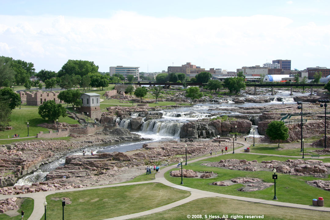
Sioux Falls as seen from the observation tower in Falls Park
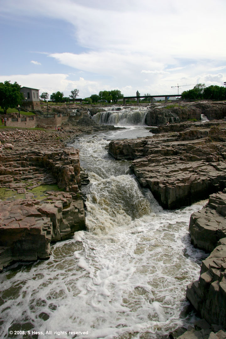
Sioux Falls from walkway to power house
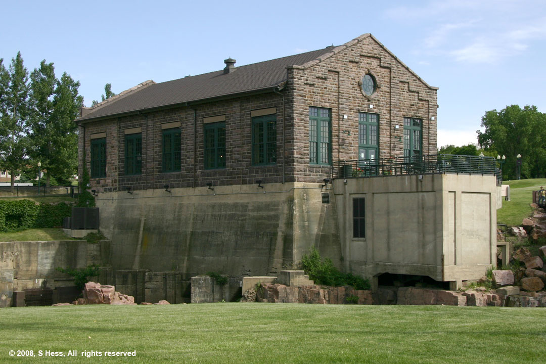
Power House
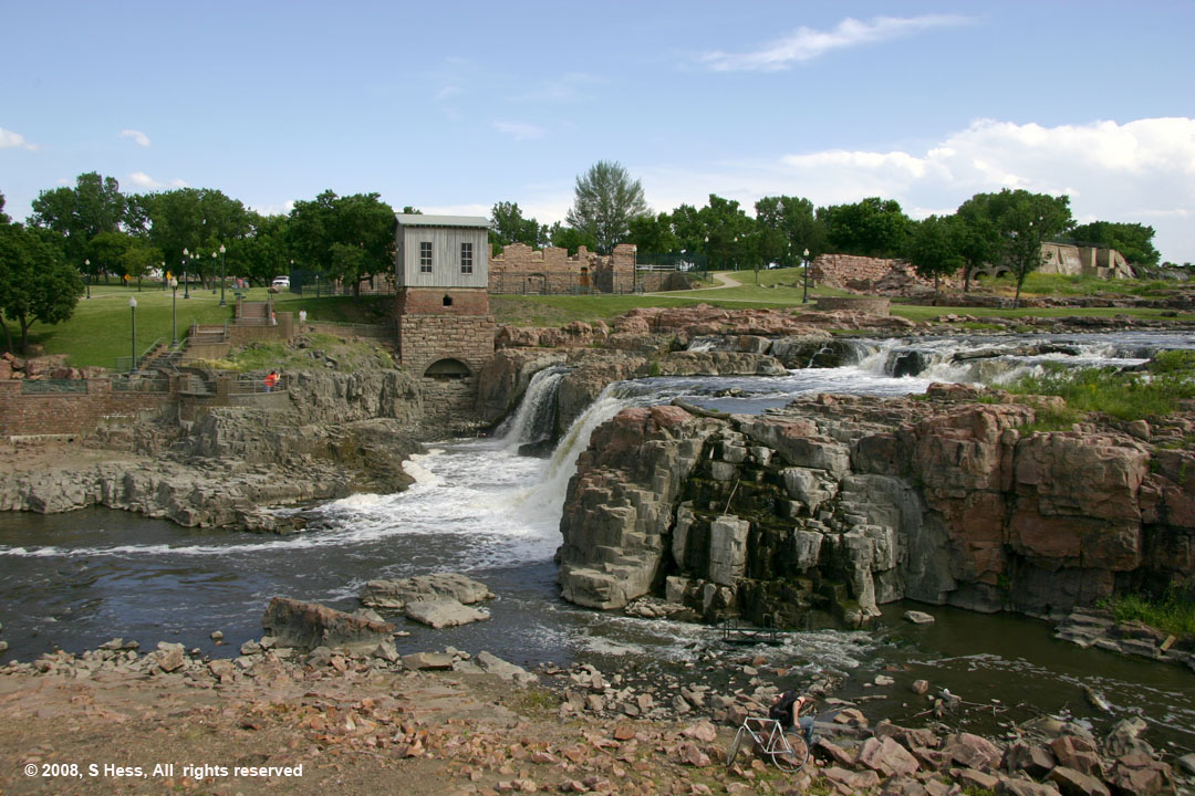
Mill ruins