
Chile - Peru 2009
Cusco - Aguas Calientes/Machu Picchu
11 November 2009
Machu Picchu General Information
Aguas Calientes General Information
Local Map
Photographs and Commentary
Click on picture to enlarge
An early morning. We were at breakfast early, checked out of the hotel and headed for the 7 am Vistadome train at the Poroy station. Due to baggage size restrictions on Peru Rail (5 Kg per person) we had to leave most of our luggage at the hotel. One of the things I left behind was my computer so I was not able to update these pages and was so far behind that I decided to wait until we got back to New York to complete these pages.
The train to Aguas Calientes runs on a narrow gauge track through the mountains, narrow gorges and valleys containing lush fields. In some of the towns, the train actually runs down the middle of the main street. The train horn is blowing constantly and the pedestrians cover their ears. I was amazed that some of the animals didn't bolt. At one point, the train has to go back and forth through a unique set of switchbacks in order to get over a pass with a grade that it would not be able to tackle straight on. Eventually the train crosses onto the eastern slope of the Andes and the rain forest that marks the beginning of the Amazon River Basin.
After a three hour ride with speeds that rarely exceeded 40 Km/H (25 MPH) we got to the Aguas Calientes station. A porter from the hotel took our one small duffle to the hotel and we met our guide who escorted us directly to the Machu Picchu bus station. The path between the train station and bus stop takes us through a market filled with stalls selling souvenirs and various crafts that are said to be authentic, The warning we got was that if you wanted authentic, buy at a store... some of the Alpaca garments in the stalls have a heavy content of synthetic fabrics. Aguas Calientes is hemmed in between the river and sheer rock walls. It has two named streets, but one of them contains the railroad tracks. The only traffic you see in town are the Machu Picchu busses and a few trucks.
The bus to Machu Picchu takes us down the main street and then up a serpentine road that brings us to the main entrance of the Machu Picchu ruins. You enter Machu Picchu by going past the Guardhouse into the lower agricultural area. This area is terraced with block walls that, like other Inca structures, are not held together with mortar. The terraces are unique engineered to make maximum use of water and create microclimates that allowed the residents to grow crops in areas that they would not normally survive. Each terrace is a filter consisting of decreasing sizes of stone and gravel, sand, charcoal and finally soil for the crops. At the higher terraces the Incas would plant legumes which release nitrogen which acts as a fertilizer for the lower terraces.
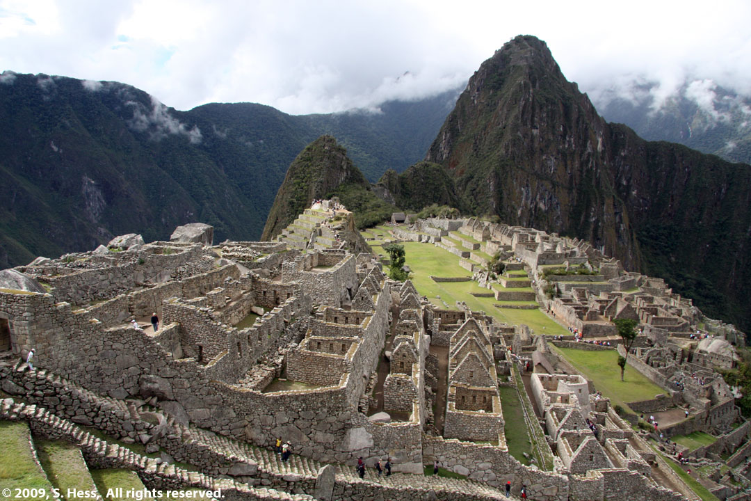
From the lower agricultural area you start to see the urban sector and the residential and ceremonial buildings of Machu Picchu. There is a main plaza that separates upper urban sector from the lower urban sector. This plaza was apparently used for civic events because it has excellent acoustics. The area on the western edge of the upper urban area contains the Temple of the Sun with its unique rounded walls. The temple was used as a solar observatory and its windows face the winter and summer solstice. Other temples including the Temple of the Condor, The Principal Temple and the Temple of the Three Windows are in this area. A small hill leads to the Intihuatana, known as the "Hitching Post of the Sun, " containing a large vertical column. The function of these columns, which are found in all major Inca centers, is unknown. Our guide's theory was that it functioned as a calendar.
The guide left us on our own after about three hours. As he left the light rain and mist dissipated and we were treated to a mostly sunny afternoon (I got a good sunburn). Some of us chose to take it easy and stay on the lower levels while the rest of us proceeded up upper agricultural area and the iconic views of Machu Picchu. I may as well have stayed on the lower level because all the pictures I took in the upper level are gone, the files corrupted. David, our Cusco guide, was a firm believer that there are a number of force fields in the Inca heartland including one in Machu Picchu. I am not inclined to believe in this, but not only did I lose a number of pictures, Susie's small camera ceased to function here. The less fantastic explanation of my lost pictures is that they were corrupted by a geo-tagging device I use to place latitude and longitude information on the picture files. Why only a few of the pictures were corrupted, I don't know. Nor do I know why Susie's camera died at Machu Picchu. I will include one picture of Machu Picchu from the upper agricultural area that was taken by my cousin, Leo. I will ask the others for their best pictures that I will add to this page at a later date.
We started heading down towards the entrance at about 3:30 pm so we could get the bus back down to Aguas Calientes. The last bus leaves around 5:40 pm. Not including the fact that I lost some good pictures, it was a great day for all of us.
.jpg)
The view from the rail station looking towards Machu Picchu. Our hotel is down the hill from this point
.jpg)
The Mercado (market) that has to be negotiated to get in and out of the rail station in Aguas Calientes
.jpg)
Heading for the bus station, bus visible through the trees on right
.jpg)
Rail station is up the stairs
.jpg)
One of the two "streets" in Aguas Calientes
Right, View down the valley from the hotel balcony. Machu Picchu is on the hill at the center
.jpg)
.jpg)
Rock wall overhanging the hotel. The only thing separating us from the wall is the railroad right of way.
Right, the view up the valley into the town of Aguas Calientes
.jpg)
.jpg)
The switchbacks on the bus route to Machu Picchu
.jpg)
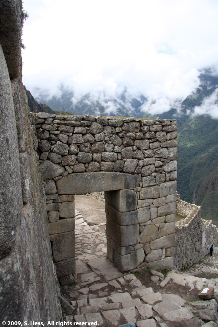
The Machu Picchu Guard House
.jpg)
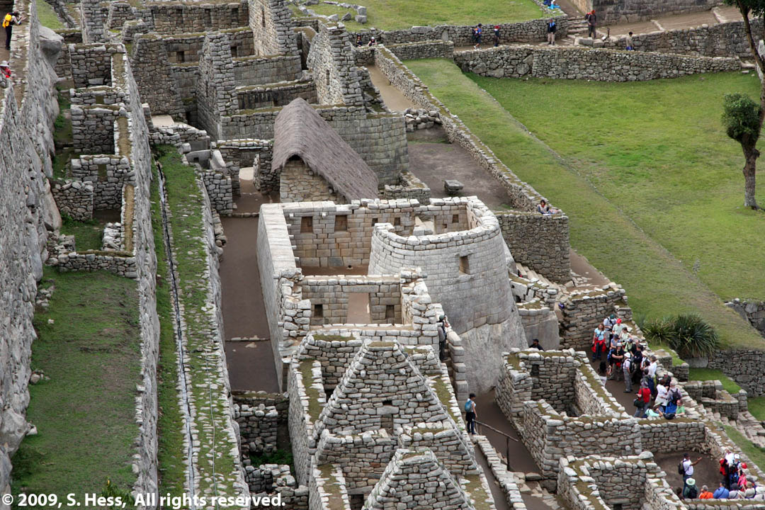
The lower urban area of Machu Picchu as seen from the terraces of the lower agricultural area. The lone tree in left center background was left as a reminder of what covered all of the ruins. They were completely overgrown by the rain forest when they were rediscovered by Hiram Bingham.
.jpg)
A view towards the guard house from the lower agricultural area
.jpg)
Susie and Sam near the Temple of the Sun with the urban area in the background
.jpg)
Agricultural terraces with the upper urban area in the background. The lighter colored building in the left center is the Temple of the Sun
.jpg)
Access steps built into the terrace walls in the lower agricultural area
.jpg)
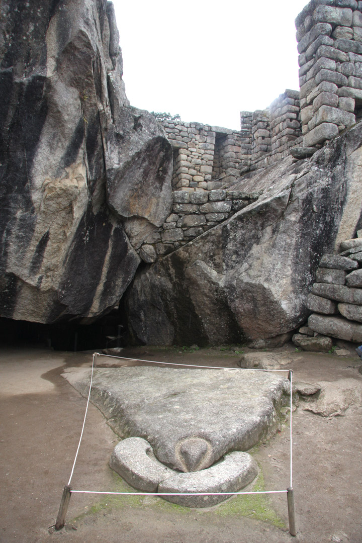
Unfinished stonework (foreground) leading to the theory that Machu Picchu was abandoned rapidly
.jpg)
Water channel leading to the fountains at the Temple of the Sun
.jpg)
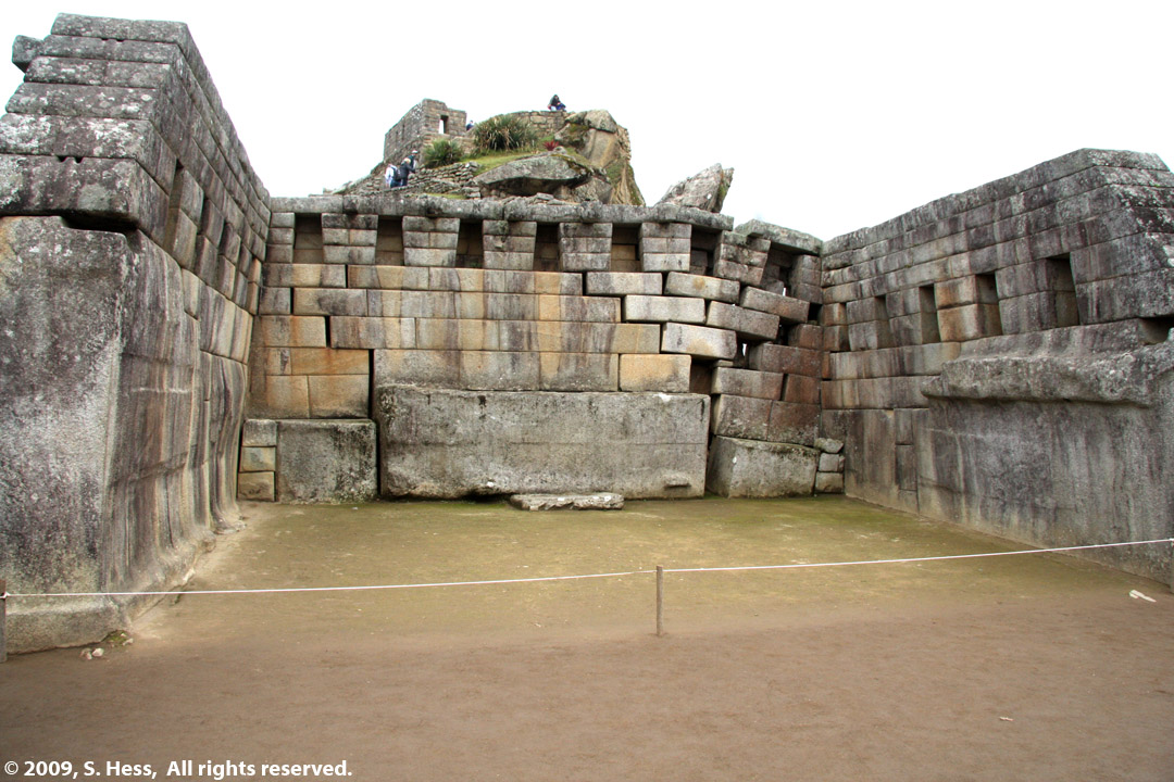
Temple of the Sun. One window points to the Summer solstice while the other points to the Winter solstice. At the time of the solstice, the sunlight strikes a flat stone in the center of the temple. Note how the Incas incorporated the existing large boulder into the structure... a common practice seen in other ruins.
.jpg)
Area beneath the Temple of the Sun. Hiram Bingham thought it was a burial place, but no mummies were found in this area.
.jpg)
Fountains at the Temple of the Sun
.jpg)
Terraces of the lower agricultural area as seen from the Temple of the Sun
.jpg)
An example of the construction method of the thatched roofs. Protruding blocks served as anchors for the vines holding the roof beams. Thatch is tied to the wooden beams.
.jpg)
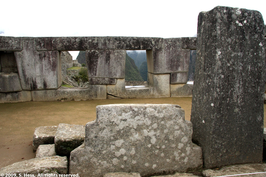
Looking west towards the Guard House from the Temple of the Sun. The terraces seen here extend further up and down the slope of the mountain.
.jpg)
The plaza separating the lower and upper urban area
.jpg)
Lost in the mist is the House of the Terrace Caretaker
.jpg)
The cousins at the urban area. Dorrie (left) and Vic (right) joined our tour group and became instant members of the family.
.jpg)
The plant at the center is the famous (infamous) Coca plant whose leaves are chewed by the natives and is made into a legal tea in most of the Andes countries. It is also infamous as the source of Cocaine.
Recovered Pictures
Corrupted pictures recovered from memory card
Principal Temple
Temple of the Three Windows. Steps in foreground represent the three levels of existance of the Incas... The Underworld (Snake), Present (puma) and Celestial World (condor).
Temple of the Sun as seen from the upper terraces
Left, Temple of the Condor
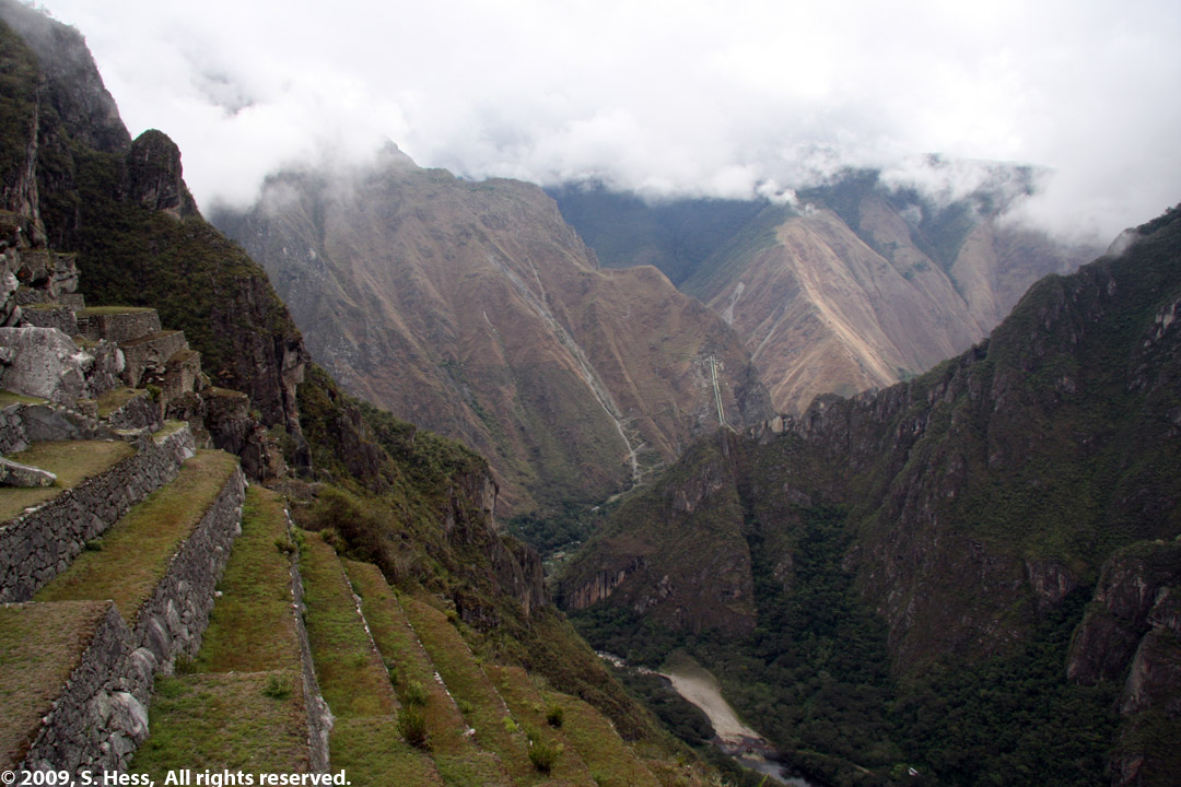
Urubamba Valley
Left, Urban Sector entrance
![]()
House of the Terrace Caretaker
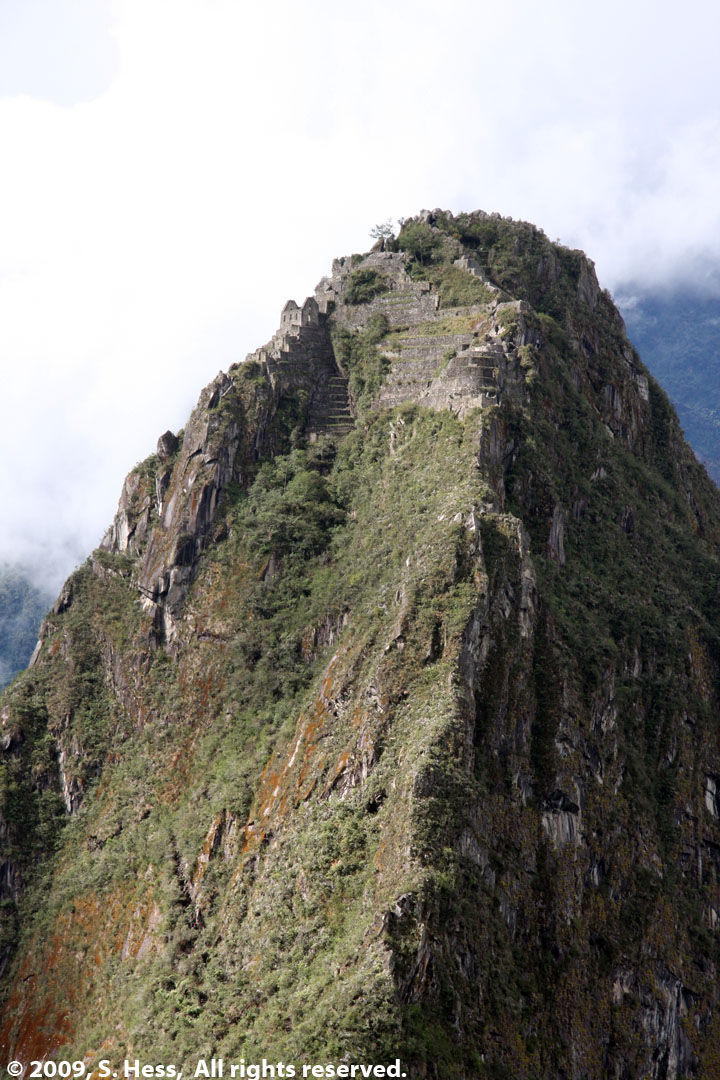
Right, Close up of Huayna Picchu taken from upper terraces
.jpg)
Pictures by Leo Levy
A number of my pictures of Machu Picchu were corrupted and I have not been able to recover them. Thanks to my cousin Leo Levy for filling in the missing scenes.
.jpg)
The Principal Temple
.jpg)
Rio Urubamba Valley as seen from the vicinity of the Sacred Plaza
.jpg)
Temple of the Three Windows
Right, Temple of the Condor. Rock, at bottom, represents the head, body and neck ruffle. The rocks in background represent the wings
.jpg)
.jpg)
Main Plaza. Note rock outcropping on the upper left (detail at right)
.jpg)
The natural feature resembles a human face. Construction above is said to represent a crown.
.jpg)
.jpg)
.jpg)
Llamas grazing on the terraces